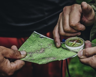
Empowering Solutions Through Geospatial Technology

Transforming data into actionable insights for humanitarian and environmental challenges.

Empowering Geospatial Solutions

At GarudaGIS, we harness geospatial technology to empower humanitarian, environmental, and public health sectors with impactful, data-driven insights.

A person is viewing a map with red data points on a computer monitor, likely indicating a geographical distribution. The image has a focus on technology and data analysis.
A person wearing a hat is leaning against large cardboard boxes labeled 'Amazon Disaster Relief' with humanitarian goods. The individual appears to be using a mobile phone. The boxes are strapped and suggest they are ready for transport or distribution. The setting appears to be outdoors with some greenery in the background.
A hand holds a portable GPS device displaying a map. The device shows navigation buttons and the brand name 'TwoNav'. The background is blurred, suggesting outdoor surroundings.

Who We Are

Our expertise focuses on developing user-friendly web-based GIS applications, ensuring accessibility for planners, field staff, and decision-makers.

Geospatial Solutions

Empowering organizations with data-driven geospatial technology for impactful real-world problem-solving.

Custom GIS Applications
Hands are holding a topographic map and a compass. One hand is pointing at a specific location on the map, indicating navigation or orientation. The map is detailed with green shades, representing terrain or elevation.

Intuitive web-based solutions for planners and field staff to enhance decision-making processes.

A control room with multiple large monitors displaying various data and maps. The environment has a modern and high-tech feel, with dim lighting creating a focused atmosphere. The screens are surrounded by numerous buttons and switches.
A handwritten note on white paper reads 'Technology with good people must bring compassion.' Below, a purple pen and a red computer mouse are placed on a patterned textile background.
Data-Driven Tools

Innovative tools designed to support humanitarian, environmental, and public health initiatives effectively.

Expert IT Consultancy

Specialized in geospatial technology

Geospatial Solutions

Empowering organizations with data-driven geospatial technology for impact.

A satellite is positioned over a coastal landscape, highlighting a stark contrast between the deep blue ocean and the arid, brown rocky terrain. The satellite features a large solar panel array and is centered in the image, capturing both natural and technological elements.
Custom GIS Applications

We develop user-friendly web-based GIS applications tailored for planners, field staff, and decision-makers to enhance their operational efficiency and effectiveness in various sectors.

A person is using a laptop on a wooden desk, viewing a map displayed on the screen. Another person is sitting nearby, partially visible. A smartphone and a pot with a green plant are also on the desk. The background is a bright blue wall.
Humanitarian Impact

Our projects focus on delivering actionable insights for humanitarian efforts, ensuring that organizations can effectively address challenges in public health, environmental sustainability, and disaster response through geospatial data.

GarudaGIS transformed our approach to geospatial data, making complex insights accessible and actionable for our team.

Kevin, Climate Change Activist

A digital map highlights various regions with differently sized red circles, indicating concentration or intensity of certain data points, overlaid on continents such as Europe, Africa, and part of Asia. Labels in white define geographical markers including oceans and continents with faint outlines in the background.
A large, spherical installation resembling a digital globe is suspended in a spacious, industrial-style indoor setting. The globe displays the Earth's continents and oceans, composed of pixelated panels. Metal structures, walkways, and glass railings surround the globe, with several people visible in the background.

★★★★★